
Projects
Private Client
Reservoir Design & Permitting
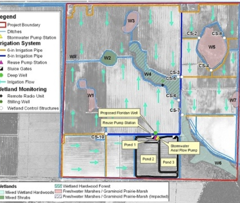
Royal Consulting Services, Inc. (RCS) provided design and permitting services for a reservoir project in Central Florida that was completed in March of 2019. This project was designed to divert stormwater and tailwater runoff to provide treatment and stormwater attenuation before discharging into North Wolf Creek. Three conceptual designs and associated cost estimates were developed to optimize potential storage and funding availability.
As part of the design effort, RCS modified an existing 100 sq. mi. SWMM hydrologic and hydraulic stormwater model, which included updating design storms, developing new hydraulic structures, and establishing new stage storage relationships. The hydrologic and hydraulic model was used to design the hydraulic infrastructure and optimize final storage and discharge elevations.
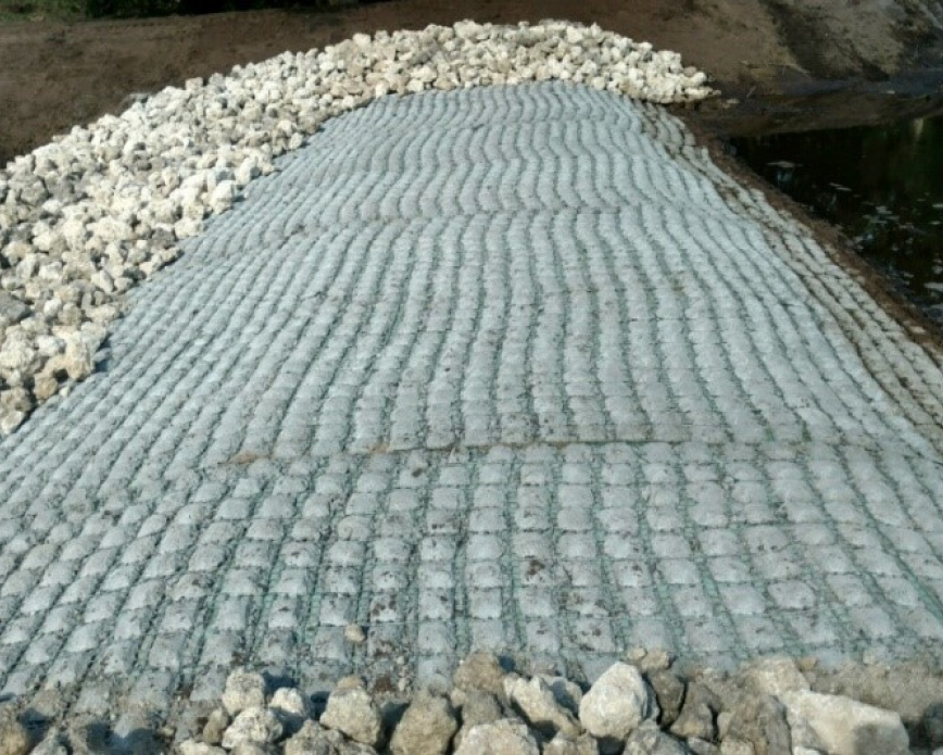
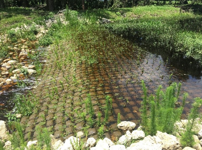
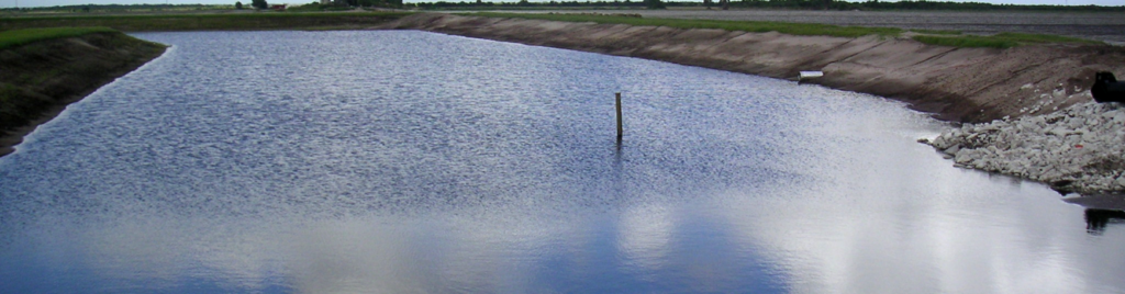
The offline reservoir was installed in a location that utilized the existing topography to maximize total storage while minimizing impacts to vegetation and existing landscape. The final design installed an innovative diversion structure specifically designed to divert water into the offline storage reservoir during low flow conditions and discharge water directly downstream during high flow conditions. The diversion structure utilized vegetative concrete block mat that allows for high flow velocity armor while promoting vegetative cover during low flow conditions. Furthermore, this structure was designed to be rapidly installed with reduced impacts to the surrounding vegetation and stream bank.
The offline reservoir was designed with two 96” full round risers for high level discharge and one 24” flashboard riser to allow for water bleed-down and management of water levels in the reservoir. This design ultimately led to a faster vegetative recovery period and a smaller construction footprint. Additional components included the construction were 900 feet of bypass channel, a 400 ft long six ft tall levee, five water control structures, one stabilized road crossing, and an emergency overflow structure. RCS also provided certification and inspection as part of final construction checkout.
Lenox Place Community
Stream Bank Stabilization Design
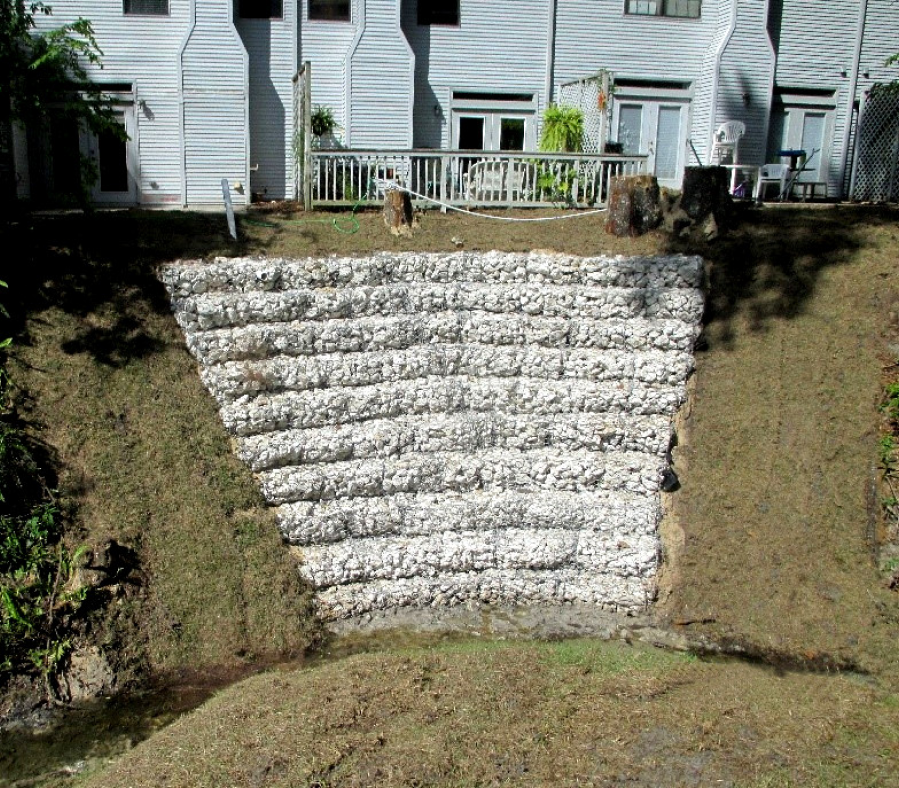
Royal Consulting Services, Inc. (RCS) was requested to investigate alternative methods and provide design engineering services to address the degradation of an existing stream bank within the Lenox Place Community, a community comprised of single family homes, townhomes, and apartments in the City of Gainesville. The stream bank was approximately 13.5 feet from top of bank down to Royal Park Creek and erosion was undermining vegetation and encroaching on the nearby townhomes on the western bank and single family homes on the eastern bank.
RCS first evaluated the proposal of a soil stabilization firm and determined the proposed method of stabilization would not sufficiently address the stream bank erosion issue. Lenox Master Homeowners Association then engaged
RCS to evaluate existing conditions of the stream bank, complete an alternatives analysis, and design and permit the appropriate solution.
The data collection effort to determine existing conditions consisted of both survey and geotechnical investigation. The survey revealed that the overall slope of the stream bank was 1 horizontal foot to 1 vertical foot (1:1 slope). The geotechnical report determined there was no immediate concern to adjacent property foundations and future concern could be alleviated by stabilizing the stream bank. In general, the preliminary report noted that the cause of the slope failure was likely due to improper stormwater management and the toppling of a large tree located in the bank.
Based on the collected information and a constructability analysis, three alternatives were proposed and evaluated, including:
- Installing gabion baskets in a vertical wall or terraced
- Constructing a sand cement bag retaining wall at the bottom of the slope
- Installing flexible concrete mats
The client chose the first option and RCS did the final design of a gabion basket retention wall in strategic locations to prevent further erosion. The design also included active soil stabilization during establishment of grasses and routing of stormwater runoff from the nearby building. This design was completed in a very restrictive construction zone due to the proximity of the buildings to the slope and completed in a phased approach that limited sediment and erosion control issues. This project was also streamlined through the Florida Department of Environmental Protection to obtain an Emergency Environmental Resource Permit to complete the construction. Once the design was complete, RCS provided detailed design plans, cost estimates, and bidding documents.
RCS was able to work with the client to expeditiously address a potential safety concern, providing an aesthetically pleasing solution for the residents of the community. In addition, the project was designed and constructed in a way that no impacts to the ecology or water quality of the stream occurred.
Florida Department of Environmental Protection
Petroleum Restoration Project (LSSI)
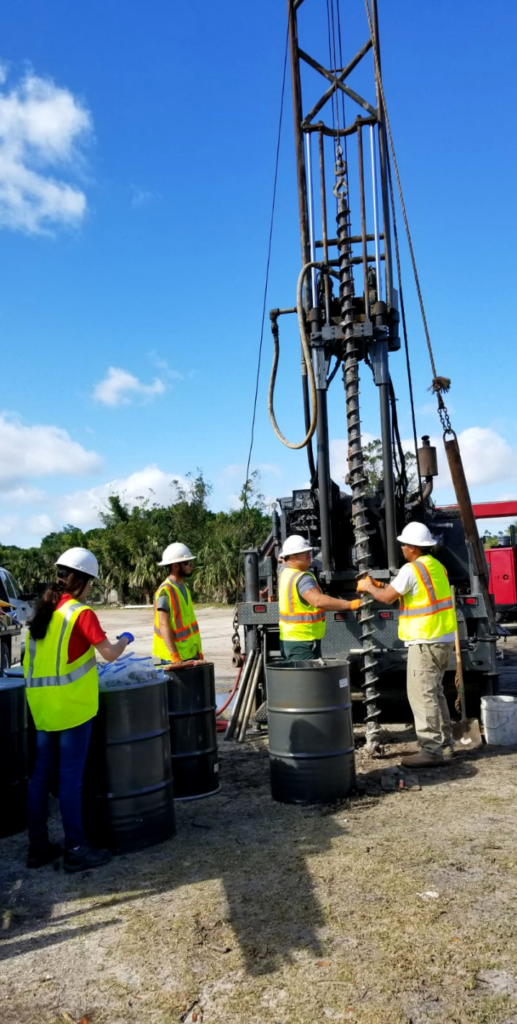
Based on the results of the LSSI assessment a Limited Remedial Action Plan (LRAP) was developed. The LRAP identified the horizontal and vertical extent of the contamination. Upon approval of the LRAP, RCS oversaw the remediation effort, which involved excavation 493 tons of soil from a 40’ by 40’ section. OVA readings were collected during the soil excavation. Excavation occurred radially outward from the plume identified until OVA readings less than 50 ppm were encountered. The excavated soil collected was then transported to the Okeechobee Landfill for ultimate disposal. Clean fill was used to bring the excavated area back to grade. Upon the completion of remedial efforts, RCS prepared a Source Removal Report presenting the results. In addition, RCS oversaw four quarters of additional groundwater quality testing to identify compliance with LSSI No Further Action criteria.
Final documentation of the remedial activities and subsequent findings from the quarterly monitoring events were submitted to the FDEP in August of 2020, demonstrating requirements for an LSSI No Further Action Order had been met and recommending that a Site Rehabilitation Closure Order be issued. These efforts lead to the successful issuance of a LSSI No Further Action Order by the FDEP in February of 2021.
Lane Southern Orchards
Farm Design Optimization
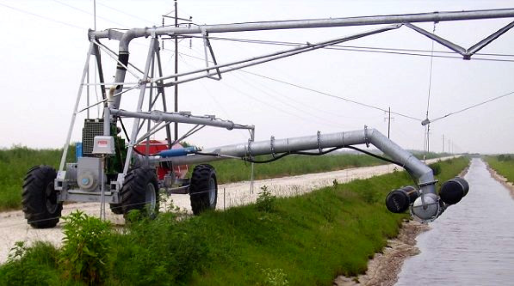
RCS worked with LSO to increase tree density, optimize harvesting routes, provide stormwater control and reduce erosion. With this framework, RCS designed primary roadways, secondary harvesting lanes, orientation for tree rows, culverts, low water crossings, and check dams.
This project was completed on an aggressive schedule, with portions of the construction underway as plans were finalized.
RCS completed four projects for Lane Southern Orchards in 2017 and 2018. The projects involved the design and development of Pecan and Peach Orchards in the State of Georgia. The orchards were developed on two 500-acre properties, one 700-acre property, and one 1,200-acre semi-contiguous property. The designs for each Orchard included primary and secondary roads, including harvesting lanes, tree orientation, tree spacing, irrigation blocks, stormwater structure design, and erosion control structures. RCS coordinated data collection, including detailed survey, reference in field survey, and wetland, soil, and hydrologic information. Pre and post hydrologic and hydraulic modeling was completed to assess site conditions and design water control structures.
Testimonial
“Our company recently developed and planted 2,500 acres of pecan and peach orchards in Middle Georgia and would not have been successful without Royal Consulting Services, Inc. as our engineering partners. Rick, Dan, and everyone at Royal, through their understanding of the needs of the grower, gave us a development plan that we used to build a state of the art project that is functional, compliant, and one that we will be very proud of for many years to come. Their knowledge, attention to detail and professional demeanor make them great partners and one of the best firms with which I have ever worked.” -Mark Sanchez, CEO, Southern Orchards Management
Cleghorn Farms
Closure of Dairy Waste Storage Ponds (WSPs)
This project achieved a total reduction in phosphorus of 99%. Not only did this project serve to protect the quality of Florida’s waters, but it also restored over 10 acres of farmable land to Cleghorn Farm.
Confidential Client
Conceptual Farm Design and Permitting for 300 Thousand Acres
In 2005, Royal Consulting Services, Inc. (RCS) provided technical guidance and planning analysis to forecast the next 20 years of water needs for a ± 300,000-acre ranch in Central Florida. These water use projections were to be used for a St. Johns River Water Management District (SJRWMD) evaluation of available future water supply. The project involved data collection and analysis of a large amount of GIS information, including topography, cover, soil type, wetlands, and features pertinent to agricultural use potential. RCS then performed an initial appraisal, reviewing the consolidated information to determine broad categories of agricultural uses that may be considered for the Ranch in years to come. A simplified water use database for various agricultural operations was provide along with a crop irrigation model and various water use permitting guidelines. With this information, RCS generated estimates of net water demand for the scenarios deemed economically viable for the Ranch.
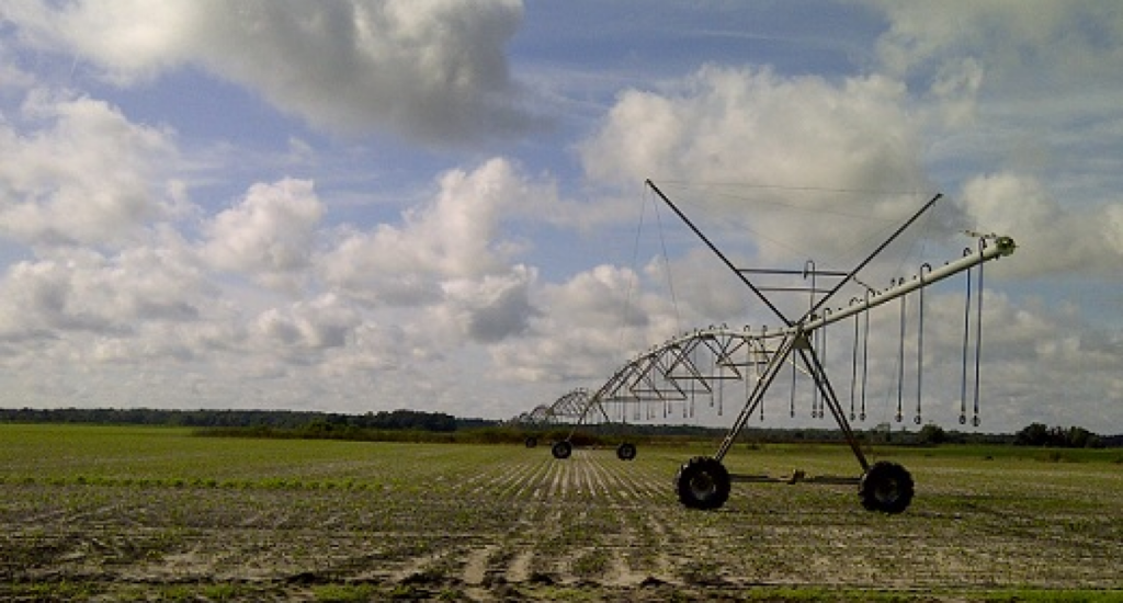
In 2008, RCS began to provide agricultural engineering expertise for the Ranch’s agricultural expansion planning project as well as the drainage design and permitting for the first set of center pivot irrigation fields. The agricultural expansion planning effort required considering a wide variety of factors that would affect the overall success of these operations. These factors included soil type and fertility, land slope, wetlands, finding large contiguous pieces of land, water supply infrastructure and potential limitations, roads, and electrical power. For the drainage design in the first set of center pivot irrigation fields, RCS used field and ditch survey data to develop a SWMM surface water model to evaluate the flooding potential. Since flood duration is typically more important than peak flood stage in agricultural settings, the results were communicated in terms of duration that a particular area would be flooded. Following this effort, an extensive field data collection effort was made to estimate ditch depth and relevant hydraulic features (e.g. culverts). This information was used to develop a regional stormwater model for the entire area that was planned to be covered by center pivots.
It was envisioned that portions of the model would be used as a starting point for more detailed drainage design efforts as the rest of the pivots are constructed. RCS continues to lead the SJRWMD ERP permitting and agricultural ERP exemption determination efforts for the proposed drainage and water supply improvements for this project.
In addition, RCS has provided and continues to provide support for the CUP permitting efforts related to this expansion. These efforts included an analysis of the District’s GWRAPPS program relative to the numerous types of crops anticipated. Since the list of crops and potential growing seasons was designed to be flexible, a customized Blaney-Criddle analysis was developed to more efficiently manage this effort. In addition, RCS provided groundwater modeling services and managed several RAI responses using information provided by a number of subconsultants.
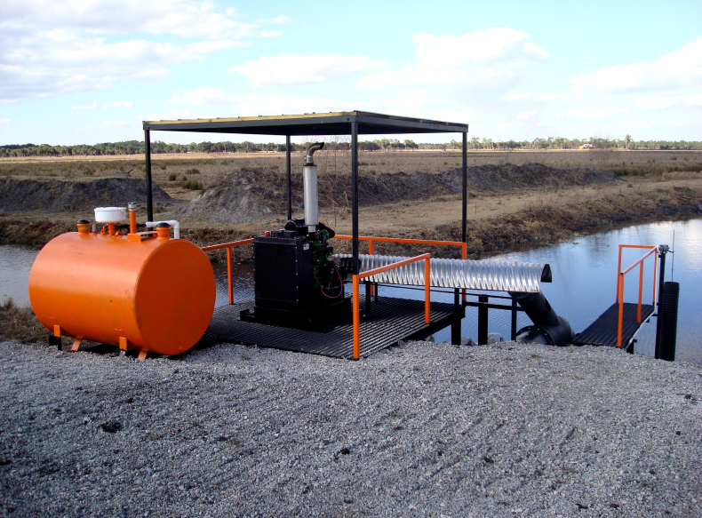
Rafter T Ranch
Florida Ranchlands Environmental Services Project
Royal Consulting Services, Inc. (RCS) completed the design of this pilot project for the South Florida Water Management District (SFWMD) and the World Wildlife Fund. The goal of the project was to evaluate the financial feasibility of paying ranchers to use portions of their land to store and attenuate excess stormwater runoff. Rafter T Ranch is a 5,200-acre cow/calf operation located in Highlands County, Florida.
Data collection efforts included survey with detailed topographic information, including existing top of bank, toe of slope, existing structures, cross sections, upstream, downstream, and center location. Surveying services also included sub-surface soil explorations and geotechnical assessments. Environmental surveying services included a Threatened and Endangered Species Survey, an Archeological Survey, and wetlands evaluations.
The project was designed to Natural Resources Conservation Service, SFWMD, and Florida Department of Transportation standards. The project allowed for up to 1,700 ac-ft of runoff to be stored in the minor impoundment and low lying pasture areas.

Design elements included:
- Conveyance improvements
- 7 control structures with diameters of up to 6 feet
- A 125-acre minor impoundment with:
- Top width of 15 feet
- 3:1 side slopes
- Height of 6.5 feet
- A 900-foot long berm with:
- Top width of 15 feet
- 3:1 side slopes
- Height of 4 feet
- A rebuilt farm access road
- A new 24” axial flow diesel stormwater pump station
- 2 modified pump stations
- Levee rehabilitation
Permitting included obtaining an Environmental Resources Permit through the SFWMD. The project scope also included development of an Operations and Maintenance manual, cost estimating, preparing bid documents, bidding services, and construction management.
B-4, Inc.
Water Quality Design and Construction Management
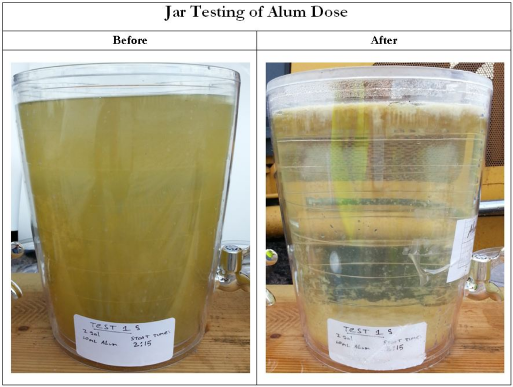
RCS completed the design and permitting of this water quality retrofit project for a 1,400-acre agricultural area. The project involved designing a stormwater reuse and treatment system for the site to meet the proposed phosphorus Total Max Daily Load (92% reduction) for areas in the northern tributaries of Lake Okeechobee. The existing and proposed stormwater systems were analyzed using a model which provided an estimation of the proposed system’s pollutant load reduction.
The project was designed to the standards of
- Over 100 new and improved culverts
- 2 minor impoundments, each with a 100 ac-ft storage/treatment capacity
- 2 stormwater pump stations, each with 2, 24-inch axial flow pumps
- 22 control structures with riser diameters ranging from 21 to 84 inches
- Over 5 miles of primary ditches with:
- Bottom widths of up to 5 feet
- 3:1 side slopes
- Depths of up to 7 feet
- Over 25 miles of conveyance swales
- Wetland rehabilitation
- Stormwater piping and irrigation piping
- Roadway crossings
- A stormwater reuse facility
- Irrigation systems
- New roadway entrances from public roads
- A telemetry system for a pump station
- A 33-foot wide concrete spillway
The project included 16 on-site, isolated wetlands with varying degrees of impact from farming activities. Many of the wetlands were being drained by ditches. During the permitting process, it was decided to include several of the wetlands in the stormwater management system. Control structures were designed to promote a more natural hydrologic cycle in the wetlands and rehabilitate them.
The project scope included data collection and analysis, obtaining survey and geotechnical data, stormwater modeling, final design, permitting, cost estimating, wetlands evaluations, a threatened & endangered species survey, an archeological survey, preparing bid documents, bidding services, and construction management.
Butler Oaks Farm, Inc. & FPPC, Inc.
Dairy Composting
Funded by Farm Pilot Project Coordination, Inc. through a congressional grant, RCS developed a comprehensive approach for managing manure solids from a 1,000-cow dairy. The primary objectives of this project were to remove 75% of nutrients from the waste stream, minimize capital costs, minimize operation & maintenance costs, maximize reuse, and produce a marketable end product. To this end, RCS designed and oversaw construction of
- a treatment system, composed of a sand separator for flush manure, in which sand and water were able to be reclaimed,
- a vat separator for solids removal, and
- a chemical injection system using ferric sulfate for additional nutrient removal.
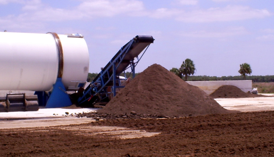
Generated solids were then further processed through a screw press loader and sent to an in-vessel composting unit with a three dayturn-around cycle to produce a “value-added” soil amendment capable of being collected and marketed off site.
The system has demonstrated the ability to reach up to a 94% reduction of phosphorus concentrations. Considerable effort throughout this project focused on the compost component. Much of the testing period was spent in optimizing the dewatering experienced in the solids settling basin was improved from 93% moisture content to 72%. As a result of this system, a total of 551 CY of soil amendment generated from the manure solids was exported offsite.
The first year revenue from the soil amendment sales was $11,020. During this time period, the daily compost production averaged 7.15 CY/day. The potential for soil amendment production from the solids generated and stored in the solids settling basins is 42 CY/day. However, the composter unit capacity is limited to 32 CY/day. During this first year of operation, a great deal of time was spent optimizing and testing the system components. If the system were to operate at the peak capacity of 32 CY/day, the projected annual soil amendment sale would be approximately $291,200.

Raulerson & Sons Ranch, Inc.
Stormwater Reuse Alternative Water Supply
Royal Consulting Services, Inc. (RCS) completed the design and permitting of this water quality retrofit and stormwater reuse project for a 670-acre agricultural area. The project involved designing a stormwater reuse and treatment system for the site to meet the proposed phosphorus Total Max Daily Load (92% reduction) for areas in the northern tributaries to Lake Okeechobee. A stormwater model was developed to analyze the existing and proposed stormwater system and to estimate the pollutant load reduction.
The project was designed to Natural Resource Conservation Service (NRCS), South Florida Water Management District (SFWMD), and Florida Department of Transportation standards. The project included the following design elements: three cell storage treatment facility, total area of 30 acres. The facility is a minor impoundment with a berm top width of 10 ft, 3:1 side slopes, and a height of 6.5 ft, stormwater pump station with two 24 inch axial flow pumps, 500 gallon diesel fuel tank, and electrical panel, radio telemetry system to control the stormwater pumps to prevent drawdown to on-site wetlands, 15 control structure risers with diameters ranging from 12 to 30 inches, a 2,000 foot long detention treatment swale, realigned 3,000 feet of farm access road, and wetlands rehydration – eight of the control structures were designed to improve the hydrology of on-site wetlands.
The design provided for 1-inch of stormwater treatment and 1.5 inches of stormwater reuse capacity in a three-cell treatment storage facility. The first cell was a 1-acre sump that allowed for sediments to settle. Cell 1 gravity flowed to Cell 2, a 19-acre treatment and storage pond, and then, to a 13-acre wetlands polishing pond. Runoff stored in Cell 2 was used to partially meet the irrigation requirements of the site. The project was also designed to meet stringent peak discharge requirements.
The project was funded by several different State and Federal agencies. $1,277,000 of funding was obtained from the SFWMD SB444 Alternative Water Supply Program, other SFWMD programs, Florida Department of Agriculture and Consumer Services, and NRCS.
Multiple Clients
Dairy Monitoring, Record Keeping, & Compliance Reporting
Many dairy operating permits issued through the FDEP require the development of a Nutrient Management Plan (NMP) for the sites. As part of these NMPs, detailed records of dairy operations and water quality are mandatory. RCS has been providing record keeping assistance to Central Florida dairies for over 20 years. Some of these dairies include: Wabasso Road Dairy, Lake Branch Dairy, Nickerson Brothers, H.W. Rucks & Son Dairy, Larson Dairy, Bishop Brothers Dairy, and Triple G Dairy.
RCS manages the collection and reporting required in meeting both the NMP and FDEP permit requirements. These records include daily operational reporting as well as detailed water use and water quality monitoring and reporting. The reporting for the data collected must be submitted at various time intervals, including monthly, quarterly, and annually. The data required for the dairy to remain in compliance is collected through several different sources including:
- Coordinating directly with the farm managers
- Monitoring herd size, pasture use, fertilizer application, wastewater application volumes, and nutrient imports vs. exports
- Dairy maintenance events
- Conducting onsite observations and meter readings
- Reviewing groundwater and pond water levels
- Collecting and analyzing rainfall data
- Utilizing automated pump data loggers
- Tracking water use for both surface water and groundwater withdrawals
- Coordinating with certified laboratories
- Analyzing groundwater and surface water quality
- Soil testing Data collected is inputted into a site-specific database
In addition, a printed project notebook summarizing the data collected is provided at each site to meet the operational permit requirements. FDEP requires Discharge Monitoring Reports (DMRs) be submitted to determine if dairies are in compliance with their permits. To prepare the DMRs, surface and groundwater samples must be obtained and analyzed. In addition, the pumped volume of water for each of the dairy’s pumps must be determined along with the highest daily peak flow during that period. Flow volumes are obtained using a combination of totalizing flow meters as well as automated data loggers depending on the situation. RCS also serves as the dairy’s onsite representative during onsite inspections by regulatory agencies, and works as a liaison between the dairy and regulatory agencies to address compliance issues through the suggestion of corrective action and coordination with contractors.